ARTICLE AD
In the cramped confines of a small cavern to the south of Paris, scientists have 'read between the lines' on the floor and discovered what could be the oldest surviving three-dimensional map of a hunter-gatherer territory.
Around 20,000 years ago, the prehistoric people who sheltered in this cave carved and smoothed the stone floors to create what looks like a miniature model of the surrounding valley, according to geoscientists Médard Thiry and Anthony Milnes.
As water from the outside world trickled through the carefully laid-out channels, basins, and depressions in the cave, the surface would have come alive with rivers, deltas, ponds, and hills.
It's not a strict geographical tracing of the outside landscape – in fact, the sides of the surrounding valley seem to be inverted on the cave floor, probably to move with the natural slope – but the features "clearly evoke a cartography," argue Thiry, from the Center of Geosciences in France, and Milnes, from the University of Adelaide in Australia.
The water flow pattern indicates a "functional, staged 'installation' of a river system" that broadly matches the valley in which the cave sits.
"The accuracy of the drawing of this hydrographical network reveals a remarkable capacity for abstract thinking in those who drew it and in those for whom it was intended," writes the team in their published paper.
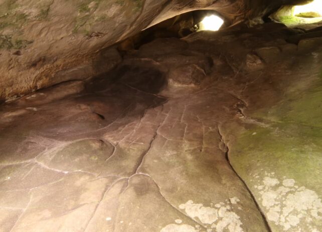 The prehistoric carvings of what could be a prehistoric 3D map in a cavern in France. (Pascal Crapet, Fontainebleau/Courtesy of Médard Thiry for labrujulaverde.com)
The cave to which this remarkable discovery belongs is called Ségognole 3, and it's part of a famous complex of sandstone structures in France that includes more than 2,000 Stone Age engravings.
Ségognole 3 is special because it dates back to the very end of the Stone Age, during the Upper Paleolithic, when human settlements first began to emerge.
Little rock art exists from this time, but recently, archaeologists found two engraved horses on the sloping wall of Ségognole 3, chiselled into the sandstone on either side of a triangle.
The grooves that were carved to make the triangle resemble a pelvis, a groin, thighs, and hips, and a channel right through the middle carried rainfall through a 'vulva'.
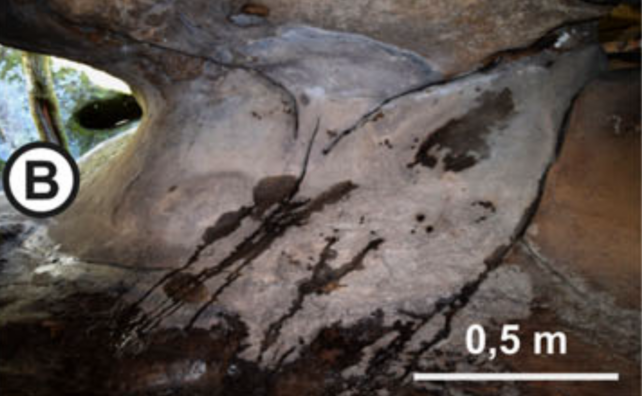 The part of the cave carved with grooves that resemble a female figure. (Thiry and Milnes, Oxford Journal of Archaeology, 2024)
Thiry and Milnes have now followed the course of this water deeper into the cave, describing a pattern of human manipulations that were previously missed.
The authors describe how water seeps into the cavern via fractures when it rains, running across the floor where it is held in depressions. The biggest and most elevated of these basins shows signs of being enlarged and deepened by human hands, and it acts like a water tower, feeding rainfall further into the cave.
Downstream, the water splits, with one arm running through the apparent pelvis and the other filling the channels of the picture map. All the 'hills' or mounds in the mini landscape are perfectly rounded and some are encircled by deep grooves.
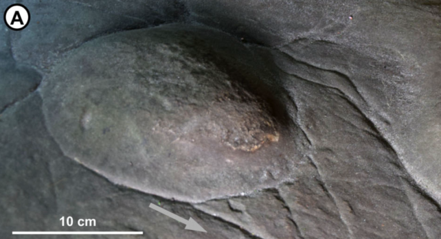 A mound on the cave floor encircled with deep grooves that may have represented a hill. (Thiry and Milnes, Oxford Journal of Archaeology, 2024)
The tortuous and meandering paths of these furrows resemble rivers, argue Thiry and Milnes, and as they converge downstream, the networks come to resemble river deltas and wetlands.
All of these features, along with the fact that there are no repeated shapes or patterns, have them thinking this is a 3D picture map of the local land.
The terrace in the cave's upper gallery could represent the surrounding valley's plateau, and the grooves running through the middle could represent the École River and its various tributaries. Some of the basins could be ponds, while the horizontal grooves seen in some areas could represent ravines or gullies in the valley. Flat bits of sandstone match up with the position of local foothills and some bulges are in the right-ish position to represent isolated hillocks.
"Rather than a geographical representation or a map of the proximal landscape, the engraved gallery floor in Ségognole 3 appears to be a representation of the spatial relationships of landscape features and may be considered a miniature of the natural features and their relationships in the adjoining landscape," explain the authors.
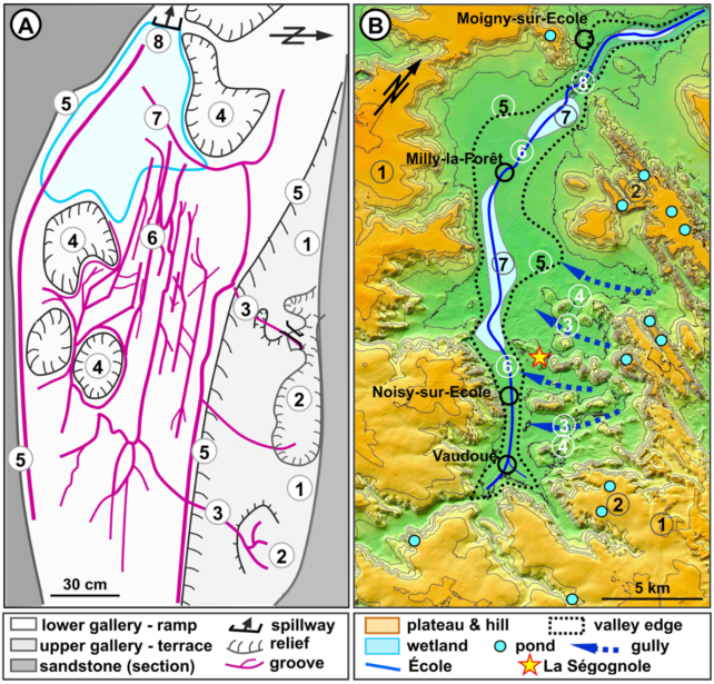 A) The carvings on the cave floor. B) A map of the local valley showing comparable patterns and features. (Thiry and Milnes, Oxford Journal of Archaeology, 2024)
While there are potentially older engravings that some interpret as maps, these are generally thought of as maps of settlements or hunting zones, not necessarily as a guide to local, natural landmarks across a whole valley.
"Any interpretation of prehistoric carvings is always subject to caution," admit Thiry and Milnes, but if this really is a picture map of the local terrain, they think prehistoric humans may have used it for hunting, education, storytelling, or for rituals concerning water.
The study was published in the Oxford Journal of Archaeology.

 20 hours ago
16

